|
|
|||||||||||||||||
| Point ID: 7519 | Downloads | Plots | Site Data | Code: 70531 |
|
|
|||||||||||||||||
| Download | |
|---|---|
| Site Descriptor Information | Site Time Series Data |
| Link to all available data | |
| View: | Time Series | All |
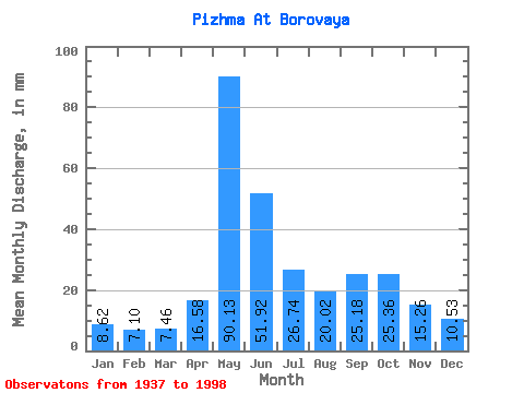
| Units: | m3/s |
| Statistic | Jan | Feb | Mar | Apr | May | Jun | Jul | Aug | Sep | Oct | Nov | Dec | Annual |
|---|---|---|---|---|---|---|---|---|---|---|---|---|---|
| Mean | 8.62 | 7.16 | 7.46 | 16.58 | 90.11 | 51.92 | 26.74 | 20.01 | 25.18 | 25.35 | 15.26 | 10.53 | 303.78 |
| Standard Deviation | 1.42 | 1.10 | 1.11 | 17.93 | 31.16 | 25.96 | 11.31 | 8.16 | 10.04 | 10.08 | 5.09 | 2.07 | 50.19 |
| Min | 5.37 | 4.81 | 5.25 | 5.51 | 36.53 | 15.00 | 11.50 | 8.76 | 8.48 | 8.60 | 7.69 | 4.22 | 154.60 |
| Max | 11.88 | 9.93 | 10.46 | 80.04 | 174.70 | 169.62 | 71.74 | 44.80 | 53.01 | 53.62 | 33.39 | 15.88 | 449.36 |
| Coefficient of Variation | 0.17 | 0.15 | 0.15 | 1.08 | 0.35 | 0.50 | 0.42 | 0.41 | 0.40 | 0.40 | 0.33 | 0.20 | 0.17 |
 Return to R-Arctic Net Home Page