|
|
|||||||||||||||||
| Point ID: 7517 | Downloads | Plots | Site Data | Code: 70528 |
|
|
|||||||||||||||||
| Download | |
|---|---|
| Site Descriptor Information | Site Time Series Data |
| Link to all available data | |
| View: | Time Series | All |
| Units: | m3/s |
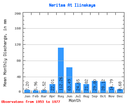
| Statistic | Jan | Feb | Mar | Apr | May | Jun | Jul | Aug | Sep | Oct | Nov | Dec | Annual |
|---|---|---|---|---|---|---|---|---|---|---|---|---|---|
| Mean | 7.20 | 6.01 | 6.52 | 22.01 | 112.25 | 63.49 | 24.64 | 21.82 | 29.80 | 28.12 | 14.79 | 8.67 | 345.35 |
| Standard Deviation | 1.05 | 0.96 | 1.12 | 24.05 | 42.41 | 36.19 | 7.70 | 12.21 | 15.70 | 10.54 | 5.35 | 1.35 | 61.34 |
| Min | 4.47 | 3.67 | 4.57 | 4.87 | 61.81 | 12.82 | 13.81 | 9.79 | 10.60 | 13.95 | 7.95 | 6.81 | 250.09 |
| Max | 9.34 | 7.36 | 9.54 | 96.66 | 227.53 | 166.82 | 41.68 | 57.39 | 58.27 | 45.10 | 30.01 | 12.62 | 509.31 |
| Coefficient of Variation | 0.15 | 0.16 | 0.17 | 1.09 | 0.38 | 0.57 | 0.31 | 0.56 | 0.53 | 0.38 | 0.36 | 0.16 | 0.18 |
 Return to R-Arctic Net Home Page