|
|
|||||||||||||||||
| Point ID: 7499 | Downloads | Plots | Site Data | Code: 70486 |
|
|
|||||||||||||||||
| Download | |
|---|---|
| Site Descriptor Information | Site Time Series Data |
| Link to all available data | |
| View: | Time Series | All |
| Units: | m3/s |
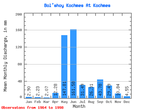
| Statistic | Jan | Feb | Mar | Apr | May | Jun | Jul | Aug | Sep | Oct | Nov | Dec | Annual |
|---|---|---|---|---|---|---|---|---|---|---|---|---|---|
| Mean | 2.90 | 2.25 | 2.07 | 12.28 | 147.79 | 161.58 | 31.49 | 26.30 | 43.78 | 29.48 | 10.84 | 4.55 | 472.65 |
| Standard Deviation | 1.53 | 1.17 | 1.16 | 34.55 | 88.88 | 112.71 | 25.16 | 23.38 | 28.57 | 18.90 | 10.82 | 1.75 | 78.77 |
| Min | 0.16 | 0.08 | 0.08 | 0.09 | 3.36 | 16.49 | 5.54 | 3.11 | 5.26 | 6.99 | 2.77 | 1.88 | 325.64 |
| Max | 5.81 | 4.97 | 4.37 | 191.29 | 308.48 | 393.69 | 99.09 | 87.36 | 127.35 | 93.36 | 66.06 | 8.63 | 680.82 |
| Coefficient of Variation | 0.53 | 0.52 | 0.56 | 2.81 | 0.60 | 0.70 | 0.80 | 0.89 | 0.65 | 0.64 | 1.00 | 0.39 | 0.17 |
 Return to R-Arctic Net Home Page