|
|
|||||||||||||||||
| Point ID: 7490 | Downloads | Plots | Site Data | Code: 70451 |
|
|
|||||||||||||||||
| Download | |
|---|---|
| Site Descriptor Information | Site Time Series Data |
| Link to all available data | |
| View: | Time Series | All |
| Units: | m3/s |
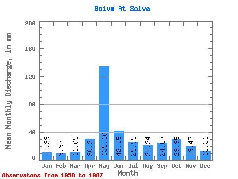
| Statistic | Jan | Feb | Mar | Apr | May | Jun | Jul | Aug | Sep | Oct | Nov | Dec | Annual |
|---|---|---|---|---|---|---|---|---|---|---|---|---|---|
| Mean | 11.39 | 10.05 | 11.05 | 30.21 | 135.08 | 42.15 | 25.95 | 21.23 | 24.87 | 29.95 | 19.47 | 13.31 | 369.16 |
| Standard Deviation | 1.44 | 1.57 | 1.25 | 26.89 | 46.14 | 19.94 | 14.36 | 12.22 | 12.60 | 12.94 | 8.10 | 2.98 | 62.91 |
| Min | 7.78 | 6.66 | 8.41 | 10.15 | 23.16 | 16.01 | 10.30 | 10.88 | 11.76 | 13.31 | 10.12 | 9.12 | 178.87 |
| Max | 15.17 | 15.07 | 13.77 | 112.37 | 209.51 | 100.94 | 68.84 | 61.59 | 62.82 | 77.66 | 47.88 | 24.57 | 475.01 |
| Coefficient of Variation | 0.13 | 0.16 | 0.11 | 0.89 | 0.34 | 0.47 | 0.55 | 0.58 | 0.51 | 0.43 | 0.42 | 0.22 | 0.17 |
 Return to R-Arctic Net Home Page