|
|
|||||||||||||||||
| Point ID: 749 | Downloads | Plots | Site Data | Code: 07GD003 |
|
|
|||||||||||||||||
| Download | |
|---|---|
| Site Descriptor Information | Site Time Series Data |
| Link to all available data | |
| View: | Time Series | All |
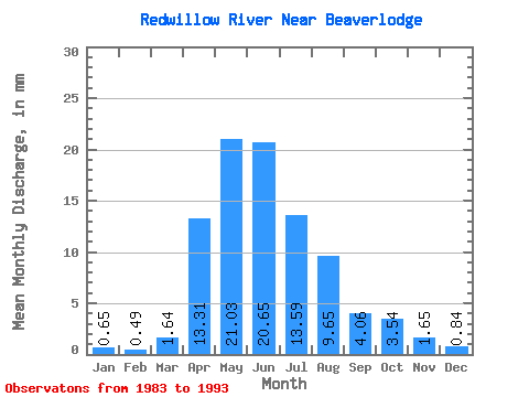
| Units: | m3/s |
| Statistic | Jan | Feb | Mar | Apr | May | Jun | Jul | Aug | Sep | Oct | Nov | Dec | Annual |
|---|---|---|---|---|---|---|---|---|---|---|---|---|---|
| Mean | 0.63 | 0.48 | 1.61 | 13.06 | 20.64 | 20.27 | 13.33 | 9.47 | 3.99 | 3.48 | 1.62 | 0.82 | 93.47 |
| Standard Deviation | 0.49 | 0.38 | 2.03 | 9.62 | 12.31 | 34.47 | 15.13 | 17.96 | 5.90 | 4.31 | 1.39 | 0.58 | 51.21 |
| Min | 0.00 | 0.00 | 0.01 | 2.40 | 3.14 | 2.46 | 0.25 | 0.06 | 0.05 | 0.10 | 0.08 | 0.04 | 28.67 |
| Max | 1.60 | 1.09 | 6.94 | 28.82 | 44.41 | 122.68 | 48.57 | 54.23 | 16.74 | 12.86 | 4.30 | 1.98 | 192.58 |
| Coefficient of Variation | 0.78 | 0.78 | 1.26 | 0.74 | 0.60 | 1.70 | 1.14 | 1.90 | 1.48 | 1.24 | 0.86 | 0.71 | 0.55 |
 Return to R-Arctic Net Home Page