|
|
|||||||||||||||||
| Point ID: 7489 | Downloads | Plots | Site Data | Code: 70449 |
|
|
|||||||||||||||||
| Download | |
|---|---|
| Site Descriptor Information | Site Time Series Data |
| Link to all available data | |
| View: | Time Series | All |
| Units: | m3/s |
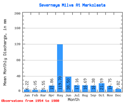
| Statistic | Jan | Feb | Mar | Apr | May | Jun | Jul | Aug | Sep | Oct | Nov | Dec | Annual |
|---|---|---|---|---|---|---|---|---|---|---|---|---|---|
| Mean | 6.22 | 5.09 | 5.55 | 15.86 | 119.68 | 38.50 | 17.16 | 16.69 | 16.38 | 21.59 | 14.75 | 7.82 | 284.28 |
| Standard Deviation | 0.78 | 0.56 | 0.65 | 14.20 | 36.13 | 23.45 | 8.11 | 16.28 | 8.06 | 10.05 | 6.44 | 1.50 | 42.23 |
| Min | 4.48 | 3.78 | 4.08 | 5.09 | 53.74 | 10.33 | 6.83 | 4.95 | 5.97 | 10.49 | 6.03 | 5.87 | 206.20 |
| Max | 7.55 | 6.24 | 6.57 | 55.23 | 194.18 | 99.76 | 36.08 | 84.11 | 30.55 | 55.12 | 32.42 | 12.15 | 378.72 |
| Coefficient of Variation | 0.13 | 0.11 | 0.12 | 0.90 | 0.30 | 0.61 | 0.47 | 0.97 | 0.49 | 0.47 | 0.44 | 0.19 | 0.15 |
 Return to R-Arctic Net Home Page