|
|
|||||||||||||||||
| Point ID: 7488 | Downloads | Plots | Site Data | Code: 70447 |
|
|
|||||||||||||||||
| Download | |
|---|---|
| Site Descriptor Information | Site Time Series Data |
| Link to all available data | |
| View: | Time Series | All |
| Units: | m3/s |
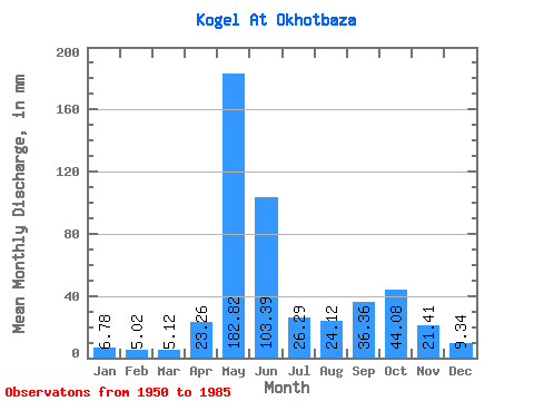
| Statistic | Jan | Feb | Mar | Apr | May | Jun | Jul | Aug | Sep | Oct | Nov | Dec | Annual |
|---|---|---|---|---|---|---|---|---|---|---|---|---|---|
| Mean | 6.77 | 5.07 | 5.12 | 23.26 | 182.80 | 103.39 | 26.29 | 24.11 | 36.36 | 44.08 | 21.41 | 9.34 | 485.56 |
| Standard Deviation | 1.47 | 0.96 | 1.03 | 28.16 | 58.59 | 58.96 | 13.30 | 20.32 | 19.75 | 21.77 | 15.48 | 2.41 | 83.93 |
| Min | 4.31 | 3.46 | 3.52 | 3.94 | 63.28 | 24.96 | 7.42 | 6.28 | 7.69 | 12.21 | 6.49 | 5.52 | 349.41 |
| Max | 11.15 | 7.88 | 8.96 | 111.28 | 285.24 | 236.29 | 55.30 | 79.72 | 91.14 | 96.28 | 69.92 | 14.07 | 686.82 |
| Coefficient of Variation | 0.22 | 0.19 | 0.20 | 1.21 | 0.32 | 0.57 | 0.51 | 0.84 | 0.54 | 0.49 | 0.72 | 0.26 | 0.17 |
 Return to R-Arctic Net Home Page