|
|
|||||||||||||||||
| Point ID: 7485 | Downloads | Plots | Site Data | Code: 70439 |
|
|
|||||||||||||||||
| Download | |
|---|---|
| Site Descriptor Information | Site Time Series Data |
| Link to all available data | |
| View: | Time Series | All |
| Units: | m3/s |
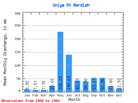
| Statistic | Jan | Feb | Mar | Apr | May | Jun | Jul | Aug | Sep | Oct | Nov | Dec | Annual |
|---|---|---|---|---|---|---|---|---|---|---|---|---|---|
| Mean | 9.92 | 7.63 | 7.75 | 23.02 | 226.18 | 140.69 | 42.02 | 38.90 | 53.17 | 52.95 | 21.61 | 12.93 | 627.71 |
| Standard Deviation | 1.24 | 0.79 | 0.87 | 24.64 | 64.64 | 75.38 | 22.45 | 24.25 | 25.57 | 24.82 | 10.65 | 2.38 | 96.83 |
| Min | 7.84 | 6.33 | 4.84 | 6.37 | 68.02 | 33.58 | 13.33 | 11.53 | 13.34 | 13.11 | 11.37 | 8.80 | 421.57 |
| Max | 12.66 | 9.32 | 9.71 | 115.93 | 329.95 | 293.10 | 94.58 | 116.39 | 96.79 | 126.56 | 61.79 | 19.32 | 865.14 |
| Coefficient of Variation | 0.12 | 0.10 | 0.11 | 1.07 | 0.29 | 0.54 | 0.53 | 0.62 | 0.48 | 0.47 | 0.49 | 0.18 | 0.15 |
 Return to R-Arctic Net Home Page