|
|
|||||||||||||||||
| Point ID: 7483 | Downloads | Plots | Site Data | Code: 70421 |
|
|
|||||||||||||||||
| Download | |
|---|---|
| Site Descriptor Information | Site Time Series Data |
| Link to all available data | |
| View: | Time Series | All |
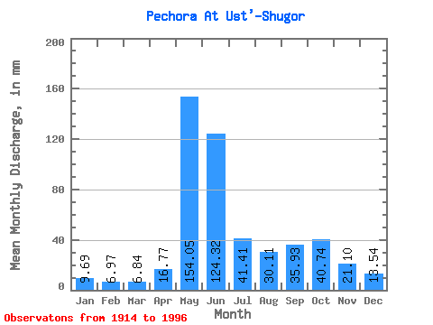
| Units: | m3/s |
| Statistic | Jan | Feb | Mar | Apr | May | Jun | Jul | Aug | Sep | Oct | Nov | Dec | Annual |
|---|---|---|---|---|---|---|---|---|---|---|---|---|---|
| Mean | 9.69 | 7.03 | 6.84 | 16.77 | 154.03 | 124.33 | 41.40 | 30.11 | 35.93 | 40.74 | 21.10 | 13.54 | 498.93 |
| Standard Deviation | 2.54 | 1.49 | 1.39 | 17.94 | 41.05 | 47.90 | 15.24 | 16.36 | 15.45 | 17.44 | 9.35 | 3.59 | 74.34 |
| Min | 5.67 | 4.26 | 4.05 | 5.76 | 60.70 | 44.93 | 16.50 | 12.46 | 10.14 | 8.73 | 9.91 | 8.01 | 297.25 |
| Max | 20.63 | 11.46 | 9.40 | 88.32 | 224.95 | 258.82 | 84.51 | 88.47 | 76.80 | 94.03 | 52.99 | 28.05 | 729.54 |
| Coefficient of Variation | 0.26 | 0.21 | 0.20 | 1.07 | 0.27 | 0.39 | 0.37 | 0.54 | 0.43 | 0.43 | 0.44 | 0.27 | 0.15 |
 Return to R-Arctic Net Home Page