|
|
|||||||||||||||||
| Point ID: 7481 | Downloads | Plots | Site Data | Code: 70410 |
|
|
|||||||||||||||||
| Download | |
|---|---|
| Site Descriptor Information | Site Time Series Data |
| Link to all available data | |
| View: | Time Series | All |
| Units: | m3/s |
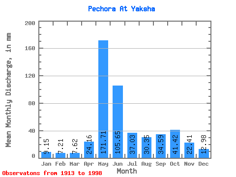
| Statistic | Jan | Feb | Mar | Apr | May | Jun | Jul | Aug | Sep | Oct | Nov | Dec | Annual |
|---|---|---|---|---|---|---|---|---|---|---|---|---|---|
| Mean | 9.15 | 7.27 | 7.62 | 24.16 | 171.68 | 105.64 | 37.02 | 30.35 | 34.59 | 41.41 | 22.41 | 12.98 | 501.82 |
| Standard Deviation | 2.02 | 1.50 | 1.29 | 25.66 | 45.94 | 51.24 | 16.49 | 18.63 | 15.76 | 17.20 | 9.48 | 2.92 | 75.48 |
| Min | 4.71 | 3.85 | 4.45 | 5.01 | 53.73 | 28.02 | 13.89 | 8.82 | 10.27 | 10.88 | 8.57 | 7.41 | 264.97 |
| Max | 17.84 | 14.84 | 13.14 | 127.71 | 283.95 | 237.38 | 89.64 | 91.59 | 69.25 | 107.45 | 54.70 | 19.07 | 695.39 |
| Coefficient of Variation | 0.22 | 0.21 | 0.17 | 1.06 | 0.27 | 0.48 | 0.45 | 0.61 | 0.46 | 0.41 | 0.42 | 0.23 | 0.15 |
 Return to R-Arctic Net Home Page