|
|
|||||||||||||||||
| Point ID: 7479 | Downloads | Plots | Site Data | Code: 70403 |
|
|
|||||||||||||||||
| Download | |
|---|---|
| Site Descriptor Information | Site Time Series Data |
| Link to all available data | |
| View: | Time Series | All |
| Units: | m3/s |
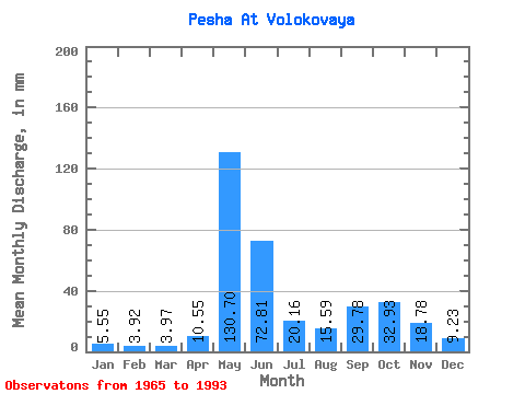
| Statistic | Jan | Feb | Mar | Apr | May | Jun | Jul | Aug | Sep | Oct | Nov | Dec | Annual |
|---|---|---|---|---|---|---|---|---|---|---|---|---|---|
| Mean | 5.55 | 3.95 | 3.96 | 10.55 | 130.69 | 72.81 | 20.16 | 15.59 | 29.78 | 32.92 | 18.78 | 9.22 | 371.90 |
| Standard Deviation | 1.97 | 1.12 | 0.89 | 12.65 | 76.76 | 53.02 | 13.13 | 12.23 | 15.17 | 14.79 | 10.20 | 4.34 | 86.18 |
| Min | 2.93 | 1.67 | 2.20 | 2.51 | 13.97 | 16.41 | 8.06 | 5.68 | 6.90 | 12.14 | 6.55 | 4.02 | 200.15 |
| Max | 10.40 | 6.31 | 6.17 | 45.03 | 220.60 | 224.70 | 59.82 | 58.76 | 62.84 | 62.52 | 45.03 | 23.41 | 500.01 |
| Coefficient of Variation | 0.35 | 0.28 | 0.23 | 1.20 | 0.59 | 0.73 | 0.65 | 0.79 | 0.51 | 0.45 | 0.54 | 0.47 | 0.23 |
 Return to R-Arctic Net Home Page