|
|
|||||||||||||||||
| Point ID: 7473 | Downloads | Plots | Site Data | Code: 70394 |
|
|
|||||||||||||||||
| Download | |
|---|---|
| Site Descriptor Information | Site Time Series Data |
| Link to all available data | |
| View: | Time Series | All |
| Units: | m3/s |
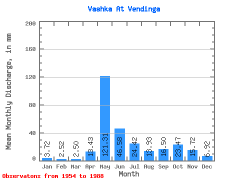
| Statistic | Jan | Feb | Mar | Apr | May | Jun | Jul | Aug | Sep | Oct | Nov | Dec | Annual |
|---|---|---|---|---|---|---|---|---|---|---|---|---|---|
| Mean | 3.72 | 2.55 | 2.50 | 13.43 | 121.29 | 46.58 | 24.42 | 13.93 | 16.50 | 23.46 | 15.72 | 6.92 | 289.05 |
| Standard Deviation | 1.07 | 0.73 | 0.64 | 20.63 | 34.03 | 20.37 | 15.33 | 15.47 | 9.00 | 14.24 | 8.67 | 3.78 | 52.73 |
| Min | 2.34 | 1.07 | 0.66 | 1.95 | 59.85 | 16.49 | 6.48 | 4.45 | 4.98 | 8.25 | 4.16 | 3.31 | 199.01 |
| Max | 7.33 | 4.20 | 3.88 | 106.95 | 178.41 | 102.86 | 64.46 | 85.56 | 36.95 | 66.76 | 41.59 | 23.17 | 445.48 |
| Coefficient of Variation | 0.29 | 0.28 | 0.26 | 1.54 | 0.28 | 0.44 | 0.63 | 1.11 | 0.55 | 0.61 | 0.55 | 0.55 | 0.18 |
 Return to R-Arctic Net Home Page