|
|
|||||||||||||||||
| Point ID: 7471 | Downloads | Plots | Site Data | Code: 70392 |
|
|
|||||||||||||||||
| Download | |
|---|---|
| Site Descriptor Information | Site Time Series Data |
| Link to all available data | |
| View: | Time Series | All |
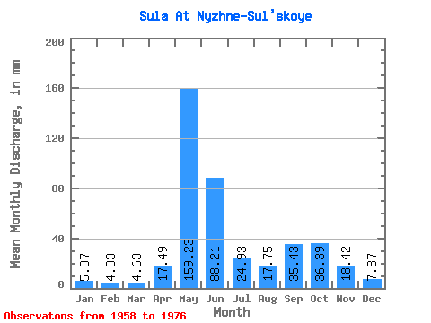
| Units: | m3/s |
| Statistic | Jan | Feb | Mar | Apr | May | Jun | Jul | Aug | Sep | Oct | Nov | Dec | Annual |
|---|---|---|---|---|---|---|---|---|---|---|---|---|---|
| Mean | 5.87 | 4.37 | 4.63 | 17.49 | 159.21 | 88.21 | 24.93 | 17.74 | 35.43 | 36.39 | 18.42 | 7.87 | 413.90 |
| Standard Deviation | 1.28 | 0.72 | 0.60 | 25.31 | 59.10 | 71.63 | 18.54 | 13.21 | 18.06 | 16.11 | 11.18 | 2.84 | 62.58 |
| Min | 3.70 | 3.42 | 3.62 | 3.46 | 33.16 | 13.70 | 8.31 | 4.79 | 10.00 | 10.41 | 6.42 | 5.30 | 309.41 |
| Max | 8.75 | 6.00 | 5.79 | 103.93 | 242.04 | 259.20 | 81.11 | 45.65 | 73.56 | 68.35 | 50.61 | 15.28 | 550.82 |
| Coefficient of Variation | 0.22 | 0.16 | 0.13 | 1.45 | 0.37 | 0.81 | 0.74 | 0.74 | 0.51 | 0.44 | 0.61 | 0.36 | 0.15 |
 Return to R-Arctic Net Home Page