|
|
|||||||||||||||||
| Point ID: 7469 | Downloads | Plots | Site Data | Code: 70390 |
|
|
|||||||||||||||||
| Download | |
|---|---|
| Site Descriptor Information | Site Time Series Data |
| Link to all available data | |
| View: | Time Series | All |
| Units: | m3/s |
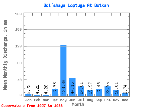
| Statistic | Jan | Feb | Mar | Apr | May | Jun | Jul | Aug | Sep | Oct | Nov | Dec | Annual |
|---|---|---|---|---|---|---|---|---|---|---|---|---|---|
| Mean | 5.71 | 4.26 | 4.28 | 17.93 | 123.36 | 44.15 | 24.01 | 15.96 | 17.48 | 23.96 | 16.01 | 8.74 | 307.66 |
| Standard Deviation | 1.41 | 1.05 | 0.75 | 24.06 | 33.11 | 21.29 | 14.77 | 14.84 | 8.59 | 11.55 | 7.29 | 3.52 | 46.68 |
| Min | 3.65 | 2.63 | 2.65 | 3.27 | 72.35 | 14.96 | 7.25 | 6.29 | 6.16 | 7.50 | 5.42 | 5.01 | 198.82 |
| Max | 9.15 | 7.54 | 6.36 | 117.48 | 194.52 | 113.61 | 61.95 | 77.94 | 43.84 | 59.56 | 35.46 | 23.18 | 400.04 |
| Coefficient of Variation | 0.25 | 0.25 | 0.18 | 1.34 | 0.27 | 0.48 | 0.61 | 0.93 | 0.49 | 0.48 | 0.46 | 0.40 | 0.15 |
 Return to R-Arctic Net Home Page