|
|
|||||||||||||||||
| Point ID: 7468 | Downloads | Plots | Site Data | Code: 70382 |
|
|
|||||||||||||||||
| Download | |
|---|---|
| Site Descriptor Information | Site Time Series Data |
| Link to all available data | |
| View: | Time Series | All |
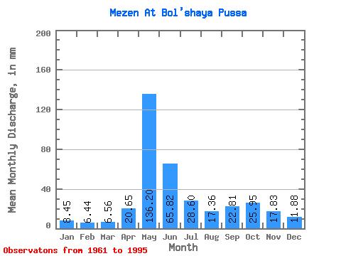
| Units: | m3/s |
| Statistic | Jan | Feb | Mar | Apr | May | Jun | Jul | Aug | Sep | Oct | Nov | Dec | Annual |
|---|---|---|---|---|---|---|---|---|---|---|---|---|---|
| Mean | 8.45 | 6.49 | 6.56 | 20.65 | 136.18 | 65.82 | 28.59 | 17.36 | 22.81 | 25.94 | 17.83 | 11.88 | 365.39 |
| Standard Deviation | 1.54 | 1.03 | 1.02 | 24.41 | 35.11 | 37.99 | 15.45 | 9.91 | 8.88 | 11.98 | 6.60 | 3.08 | 56.24 |
| Min | 6.12 | 4.85 | 4.81 | 5.60 | 58.05 | 18.84 | 12.39 | 9.00 | 10.13 | 13.24 | 9.35 | 7.40 | 242.12 |
| Max | 12.66 | 9.43 | 8.93 | 105.61 | 202.93 | 175.48 | 82.00 | 56.55 | 46.37 | 68.70 | 34.29 | 23.45 | 518.63 |
| Coefficient of Variation | 0.18 | 0.16 | 0.16 | 1.18 | 0.26 | 0.58 | 0.54 | 0.57 | 0.39 | 0.46 | 0.37 | 0.26 | 0.15 |
 Return to R-Arctic Net Home Page