|
|
|||||||||||||||||
| Point ID: 7467 | Downloads | Plots | Site Data | Code: 70378 |
|
|
|||||||||||||||||
| Download | |
|---|---|
| Site Descriptor Information | Site Time Series Data |
| Link to all available data | |
| View: | Time Series | All |
| Units: | m3/s |
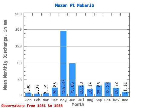
| Statistic | Jan | Feb | Mar | Apr | May | Jun | Jul | Aug | Sep | Oct | Nov | Dec | Annual |
|---|---|---|---|---|---|---|---|---|---|---|---|---|---|
| Mean | 8.90 | 7.03 | 7.19 | 20.86 | 156.85 | 79.86 | 26.23 | 18.14 | 25.83 | 33.37 | 20.72 | 11.11 | 389.18 |
| Standard Deviation | 5.36 | 4.36 | 5.11 | 30.83 | 96.72 | 79.79 | 11.93 | 8.70 | 13.46 | 17.14 | 11.67 | 3.47 | 67.55 |
| Min | 5.11 | 4.62 | 4.73 | 4.74 | 58.96 | 21.98 | 11.58 | 9.22 | 9.60 | 8.76 | 6.07 | 5.61 | 260.96 |
| Max | 46.92 | 38.59 | 44.84 | 159.14 | 801.32 | 590.74 | 61.45 | 49.82 | 60.68 | 88.85 | 68.72 | 21.34 | 561.68 |
| Coefficient of Variation | 0.60 | 0.62 | 0.71 | 1.48 | 0.62 | 1.00 | 0.46 | 0.48 | 0.52 | 0.51 | 0.56 | 0.31 | 0.17 |
 Return to R-Arctic Net Home Page