|
|
|||||||||||||||||
| Point ID: 7466 | Downloads | Plots | Site Data | Code: 70377 |
|
|
|||||||||||||||||
| Download | |
|---|---|
| Site Descriptor Information | Site Time Series Data |
| Link to all available data | |
| View: | Time Series | All |
| Units: | m3/s |
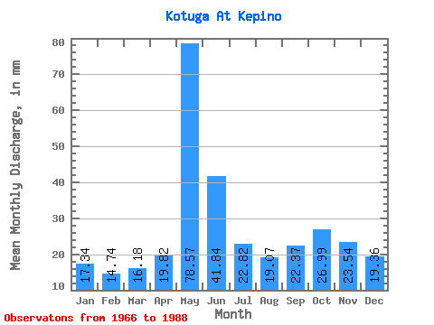
| Statistic | Jan | Feb | Mar | Apr | May | Jun | Jul | Aug | Sep | Oct | Nov | Dec | Annual |
|---|---|---|---|---|---|---|---|---|---|---|---|---|---|
| Mean | 17.34 | 14.87 | 16.17 | 19.82 | 78.56 | 41.84 | 22.82 | 19.07 | 22.37 | 26.98 | 23.55 | 19.35 | 321.20 |
| Standard Deviation | 2.45 | 2.13 | 1.81 | 8.71 | 18.04 | 13.97 | 8.78 | 4.29 | 8.02 | 7.16 | 7.20 | 5.24 | 39.05 |
| Min | 12.52 | 11.04 | 13.42 | 13.25 | 57.50 | 24.24 | 14.52 | 13.52 | 14.94 | 16.70 | 15.70 | 9.36 | 276.29 |
| Max | 22.84 | 19.38 | 20.48 | 50.31 | 119.09 | 78.52 | 44.74 | 29.46 | 40.86 | 43.32 | 42.23 | 32.45 | 387.14 |
| Coefficient of Variation | 0.14 | 0.14 | 0.11 | 0.44 | 0.23 | 0.33 | 0.39 | 0.23 | 0.36 | 0.27 | 0.31 | 0.27 | 0.12 |
 Return to R-Arctic Net Home Page