|
|
|||||||||||||||||
| Point ID: 7465 | Downloads | Plots | Site Data | Code: 70376 |
|
|
|||||||||||||||||
| Download | |
|---|---|
| Site Descriptor Information | Site Time Series Data |
| Link to all available data | |
| View: | Time Series | All |
| Units: | m3/s |
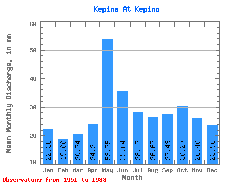
| Statistic | Jan | Feb | Mar | Apr | May | Jun | Jul | Aug | Sep | Oct | Nov | Dec | Annual |
|---|---|---|---|---|---|---|---|---|---|---|---|---|---|
| Mean | 22.38 | 19.16 | 20.73 | 24.21 | 53.74 | 35.64 | 28.16 | 26.66 | 27.48 | 30.27 | 26.40 | 23.95 | 337.36 |
| Standard Deviation | 3.18 | 3.16 | 3.21 | 7.48 | 13.78 | 12.65 | 5.39 | 6.43 | 6.14 | 6.97 | 5.13 | 4.08 | 49.48 |
| Min | 16.20 | 13.79 | 15.05 | 14.84 | 21.10 | 20.23 | 17.11 | 16.63 | 17.18 | 18.59 | 16.20 | 16.65 | 237.74 |
| Max | 28.94 | 24.99 | 26.13 | 43.48 | 85.74 | 72.74 | 45.78 | 46.22 | 43.48 | 46.87 | 41.39 | 32.40 | 423.98 |
| Coefficient of Variation | 0.14 | 0.17 | 0.15 | 0.31 | 0.26 | 0.35 | 0.19 | 0.24 | 0.22 | 0.23 | 0.19 | 0.17 | 0.15 |
 Return to R-Arctic Net Home Page