|
|
|||||||||||||||||
| Point ID: 7462 | Downloads | Plots | Site Data | Code: 70366 |
|
|
|||||||||||||||||
| Download | |
|---|---|
| Site Descriptor Information | Site Time Series Data |
| Link to all available data | |
| View: | Time Series | All |
| Units: | m3/s |
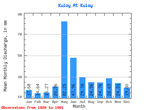
| Statistic | Jan | Feb | Mar | Apr | May | Jun | Jul | Aug | Sep | Oct | Nov | Dec | Annual |
|---|---|---|---|---|---|---|---|---|---|---|---|---|---|
| Mean | 17.68 | 14.77 | 15.27 | 20.96 | 82.24 | 47.96 | 29.78 | 24.95 | 24.76 | 28.68 | 24.31 | 19.80 | 347.61 |
| Standard Deviation | 2.82 | 2.13 | 2.11 | 13.12 | 34.34 | 25.14 | 6.66 | 7.31 | 6.93 | 8.19 | 7.72 | 4.07 | 65.85 |
| Min | 9.95 | 8.59 | 9.51 | 10.23 | 27.22 | 19.87 | 15.24 | 13.65 | 13.04 | 13.04 | 11.08 | 9.60 | 213.69 |
| Max | 24.58 | 20.39 | 20.44 | 85.09 | 174.42 | 198.66 | 50.92 | 54.97 | 47.92 | 55.76 | 49.62 | 29.86 | 500.22 |
| Coefficient of Variation | 0.16 | 0.14 | 0.14 | 0.63 | 0.42 | 0.52 | 0.22 | 0.29 | 0.28 | 0.29 | 0.32 | 0.21 | 0.19 |
 Return to R-Arctic Net Home Page