|
|
|||||||||||||||||
| Point ID: 746 | Downloads | Plots | Site Data | Code: 07GC002 |
|
|
|||||||||||||||||
| Download | |
|---|---|
| Site Descriptor Information | Site Time Series Data |
| Link to all available data | |
| View: | Time Series | All |
| Units: | m3/s |
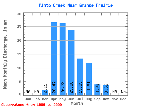
| Statistic | Jan | Feb | Mar | Apr | May | Jun | Jul | Aug | Sep | Oct | Nov | Dec | Annual |
|---|---|---|---|---|---|---|---|---|---|---|---|---|---|
| Mean | 2.11 | 26.47 | 26.22 | 23.86 | 13.35 | 11.91 | 3.99 | 3.65 | |||||
| Standard Deviation | 3.95 | 17.94 | 19.39 | 31.32 | 14.19 | 22.05 | 5.08 | 3.32 | |||||
| Min | 0.02 | 3.30 | 3.76 | 3.42 | 0.76 | 0.23 | 0.30 | 0.30 | |||||
| Max | 15.76 | 56.73 | 70.44 | 124.39 | 46.52 | 75.82 | 18.95 | 9.36 | |||||
| Coefficient of Variation | 1.87 | 0.68 | 0.74 | 1.31 | 1.06 | 1.85 | 1.27 | 0.91 |
 Return to R-Arctic Net Home Page