|
|
|||||||||||||||||
| Point ID: 7454 | Downloads | Plots | Site Data | Code: 70355 |
|
|
|||||||||||||||||
| Download | |
|---|---|
| Site Descriptor Information | Site Time Series Data |
| Link to all available data | |
| View: | Time Series | All |
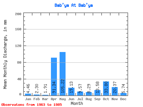
| Units: | m3/s |
| Statistic | Jan | Feb | Mar | Apr | May | Jun | Jul | Aug | Sep | Oct | Nov | Dec | Annual |
|---|---|---|---|---|---|---|---|---|---|---|---|---|---|
| Mean | 4.34 | 2.08 | 1.91 | 91.29 | 105.41 | 18.96 | 9.29 | 8.20 | 13.77 | 33.87 | 20.55 | 5.78 | 402.85 |
| Standard Deviation | 5.33 | 1.89 | 1.45 | 48.59 | 54.73 | 17.38 | 11.58 | 12.02 | 15.84 | 23.55 | 19.98 | 4.23 | 157.98 |
| Min | 0.64 | 0.58 | 0.64 | 0.62 | 40.81 | 3.70 | 1.27 | 0.64 | 0.62 | 0.64 | 0.62 | 0.64 | 254.86 |
| Max | 17.85 | 5.23 | 4.46 | 168.48 | 189.37 | 67.89 | 42.72 | 42.08 | 55.54 | 72.69 | 55.54 | 14.66 | 569.21 |
| Coefficient of Variation | 1.23 | 0.91 | 0.76 | 0.53 | 0.52 | 0.92 | 1.25 | 1.47 | 1.15 | 0.69 | 0.97 | 0.73 | 0.39 |
 Return to R-Arctic Net Home Page