|
|
|||||||||||||||||
| Point ID: 7451 | Downloads | Plots | Site Data | Code: 70351 |
|
|
|||||||||||||||||
| Download | |
|---|---|
| Site Descriptor Information | Site Time Series Data |
| Link to all available data | |
| View: | Time Series | All |
| Units: | m3/s |
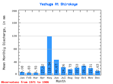
| Statistic | Jan | Feb | Mar | Apr | May | Jun | Jul | Aug | Sep | Oct | Nov | Dec | Annual |
|---|---|---|---|---|---|---|---|---|---|---|---|---|---|
| Mean | 9.08 | 6.89 | 6.93 | 27.02 | 118.32 | 46.67 | 24.05 | 17.73 | 22.53 | 28.10 | 21.31 | 12.63 | 338.23 |
| Standard Deviation | 1.69 | 1.21 | 0.77 | 29.54 | 22.91 | 24.92 | 13.90 | 9.88 | 12.20 | 9.37 | 12.76 | 3.06 | 51.18 |
| Min | 6.47 | 5.24 | 5.29 | 5.84 | 66.34 | 20.26 | 11.39 | 8.90 | 10.30 | 10.26 | 7.26 | 6.50 | 244.06 |
| Max | 12.89 | 10.14 | 7.82 | 102.50 | 153.61 | 91.44 | 63.89 | 47.31 | 50.92 | 41.05 | 51.58 | 17.26 | 431.28 |
| Coefficient of Variation | 0.19 | 0.18 | 0.11 | 1.09 | 0.19 | 0.53 | 0.58 | 0.56 | 0.54 | 0.33 | 0.60 | 0.24 | 0.15 |
 Return to R-Arctic Net Home Page