|
|
|||||||||||||||||
| Point ID: 7450 | Downloads | Plots | Site Data | Code: 70348 |
|
|
|||||||||||||||||
| Download | |
|---|---|
| Site Descriptor Information | Site Time Series Data |
| Link to all available data | |
| View: | Time Series | All |
| Units: | m3/s |
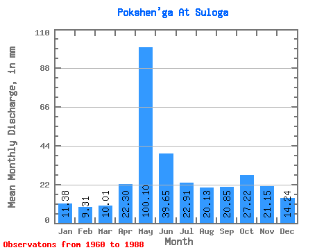
| Statistic | Jan | Feb | Mar | Apr | May | Jun | Jul | Aug | Sep | Oct | Nov | Dec | Annual |
|---|---|---|---|---|---|---|---|---|---|---|---|---|---|
| Mean | 11.38 | 9.38 | 10.01 | 22.30 | 100.08 | 39.65 | 22.91 | 20.13 | 20.85 | 27.21 | 21.15 | 14.23 | 315.60 |
| Standard Deviation | 1.54 | 0.88 | 0.82 | 19.80 | 26.83 | 17.80 | 11.66 | 14.57 | 9.20 | 12.13 | 7.95 | 3.86 | 56.50 |
| Min | 8.12 | 7.94 | 8.53 | 8.73 | 42.10 | 17.34 | 11.95 | 9.73 | 10.54 | 10.40 | 9.60 | 9.29 | 209.17 |
| Max | 14.93 | 11.32 | 11.95 | 97.90 | 154.13 | 79.25 | 64.16 | 74.27 | 41.68 | 68.68 | 36.36 | 25.43 | 430.17 |
| Coefficient of Variation | 0.14 | 0.09 | 0.08 | 0.89 | 0.27 | 0.45 | 0.51 | 0.72 | 0.44 | 0.45 | 0.38 | 0.27 | 0.18 |
 Return to R-Arctic Net Home Page