|
|
|||||||||||||||||
| Point ID: 745 | Downloads | Plots | Site Data | Code: 07GB002 |
|
|
|||||||||||||||||
| Download | |
|---|---|
| Site Descriptor Information | Site Time Series Data |
| Link to all available data | |
| View: | Time Series | All |
| Units: | m3/s |
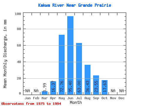
| Statistic | Jan | Feb | Mar | Apr | May | Jun | Jul | Aug | Sep | Oct | Nov | Dec | Annual |
|---|---|---|---|---|---|---|---|---|---|---|---|---|---|
| Mean | 3.99 | 16.37 | 72.75 | 95.40 | 62.99 | 36.42 | 23.55 | 17.62 | |||||
| Standard Deviation | 2.82 | 9.76 | 24.44 | 37.59 | 36.08 | 30.53 | 13.29 | 10.31 | |||||
| Min | 1.32 | 7.25 | 34.90 | 38.57 | 18.75 | 9.90 | 6.73 | 6.53 | |||||
| Max | 12.58 | 34.48 | 143.64 | 183.80 | 174.48 | 116.05 | 43.59 | 43.74 | |||||
| Coefficient of Variation | 0.71 | 0.60 | 0.34 | 0.39 | 0.57 | 0.84 | 0.56 | 0.58 |
 Return to R-Arctic Net Home Page