|
|
|||||||||||||||||
| Point ID: 7449 | Downloads | Plots | Site Data | Code: 70346 |
|
|
|||||||||||||||||
| Download | |
|---|---|
| Site Descriptor Information | Site Time Series Data |
| Link to all available data | |
| View: | Time Series | All |
| Units: | m3/s |
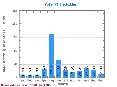
| Statistic | Jan | Feb | Mar | Apr | May | Jun | Jul | Aug | Sep | Oct | Nov | Dec | Annual |
|---|---|---|---|---|---|---|---|---|---|---|---|---|---|
| Mean | 8.49 | 6.63 | 6.98 | 25.40 | 128.58 | 51.99 | 23.38 | 17.02 | 20.04 | 27.65 | 22.39 | 12.00 | 349.29 |
| Standard Deviation | 1.80 | 1.29 | 0.95 | 33.95 | 28.34 | 27.73 | 15.29 | 11.65 | 11.69 | 11.17 | 13.19 | 4.03 | 70.21 |
| Min | 6.04 | 4.31 | 5.25 | 5.88 | 86.62 | 20.90 | 9.58 | 8.23 | 8.09 | 9.58 | 7.50 | 7.26 | 225.92 |
| Max | 12.93 | 9.34 | 9.09 | 129.31 | 175.08 | 103.33 | 60.94 | 48.80 | 45.40 | 47.09 | 53.85 | 22.02 | 465.25 |
| Coefficient of Variation | 0.21 | 0.19 | 0.14 | 1.34 | 0.22 | 0.53 | 0.65 | 0.69 | 0.58 | 0.40 | 0.59 | 0.34 | 0.20 |
 Return to R-Arctic Net Home Page