|
|
|||||||||||||||||
| Point ID: 7448 | Downloads | Plots | Site Data | Code: 70345 |
|
|
|||||||||||||||||
| Download | |
|---|---|
| Site Descriptor Information | Site Time Series Data |
| Link to all available data | |
| View: | Time Series | All |
| Units: | m3/s |
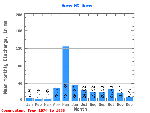
| Statistic | Jan | Feb | Mar | Apr | May | Jun | Jul | Aug | Sep | Oct | Nov | Dec | Annual |
|---|---|---|---|---|---|---|---|---|---|---|---|---|---|
| Mean | 6.04 | 4.51 | 4.89 | 28.74 | 124.32 | 36.87 | 24.61 | 19.91 | 20.34 | 27.43 | 18.97 | 9.27 | 328.24 |
| Standard Deviation | 1.53 | 0.81 | 0.76 | 36.94 | 35.03 | 13.42 | 16.07 | 18.57 | 10.85 | 12.29 | 11.86 | 4.24 | 47.26 |
| Min | 3.69 | 3.54 | 4.09 | 5.31 | 63.16 | 18.46 | 6.32 | 6.01 | 5.38 | 9.93 | 5.84 | 5.15 | 219.73 |
| Max | 9.12 | 6.38 | 6.27 | 142.81 | 193.27 | 58.69 | 64.93 | 74.02 | 38.63 | 46.49 | 47.19 | 22.31 | 395.49 |
| Coefficient of Variation | 0.25 | 0.18 | 0.16 | 1.28 | 0.28 | 0.36 | 0.65 | 0.93 | 0.53 | 0.45 | 0.62 | 0.46 | 0.14 |
 Return to R-Arctic Net Home Page