|
|
|||||||||||||||||
| Point ID: 7447 | Downloads | Plots | Site Data | Code: 70344 |
|
|
|||||||||||||||||
| Download | |
|---|---|
| Site Descriptor Information | Site Time Series Data |
| Link to all available data | |
| View: | Time Series | All |
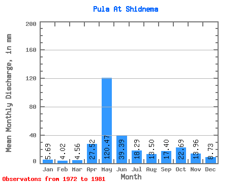
| Units: | m3/s |
| Statistic | Jan | Feb | Mar | Apr | May | Jun | Jul | Aug | Sep | Oct | Nov | Dec | Annual |
|---|---|---|---|---|---|---|---|---|---|---|---|---|---|
| Mean | 5.69 | 4.05 | 4.56 | 27.52 | 120.45 | 39.39 | 18.29 | 13.50 | 17.40 | 22.69 | 13.96 | 8.73 | 294.92 |
| Standard Deviation | 1.44 | 0.79 | 0.89 | 26.14 | 39.12 | 14.82 | 13.81 | 9.57 | 11.55 | 10.08 | 9.73 | 3.37 | 37.01 |
| Min | 3.12 | 2.75 | 3.12 | 3.65 | 69.58 | 20.40 | 5.91 | 6.45 | 8.54 | 10.56 | 6.54 | 6.28 | 245.20 |
| Max | 7.94 | 5.17 | 5.74 | 72.60 | 174.46 | 62.42 | 51.93 | 35.64 | 47.63 | 35.64 | 38.11 | 14.87 | 373.00 |
| Coefficient of Variation | 0.25 | 0.20 | 0.19 | 0.95 | 0.33 | 0.38 | 0.76 | 0.71 | 0.66 | 0.44 | 0.70 | 0.39 | 0.12 |
 Return to R-Arctic Net Home Page