|
|
|||||||||||||||||
| Point ID: 7445 | Downloads | Plots | Site Data | Code: 70340 |
|
|
|||||||||||||||||
| Download | |
|---|---|
| Site Descriptor Information | Site Time Series Data |
| Link to all available data | |
| View: | Time Series | All |
| Units: | m3/s |
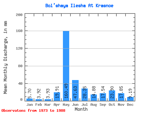
| Statistic | Jan | Feb | Mar | Apr | May | Jun | Jul | Aug | Sep | Oct | Nov | Dec | Annual |
|---|---|---|---|---|---|---|---|---|---|---|---|---|---|
| Mean | 5.70 | 3.95 | 3.93 | 19.91 | 160.47 | 47.63 | 28.35 | 14.88 | 17.54 | 23.90 | 17.85 | 9.19 | 352.01 |
| Standard Deviation | 2.31 | 1.47 | 1.06 | 33.85 | 42.91 | 21.47 | 22.27 | 13.60 | 7.80 | 13.49 | 12.77 | 5.29 | 48.16 |
| Min | 3.14 | 2.40 | 2.68 | 3.49 | 63.15 | 20.48 | 6.94 | 5.16 | 6.61 | 5.79 | 5.30 | 4.12 | 252.51 |
| Max | 10.84 | 7.11 | 5.98 | 136.64 | 226.47 | 97.28 | 78.85 | 60.83 | 31.84 | 58.52 | 47.68 | 25.79 | 414.14 |
| Coefficient of Variation | 0.41 | 0.37 | 0.27 | 1.70 | 0.27 | 0.45 | 0.79 | 0.91 | 0.45 | 0.56 | 0.71 | 0.58 | 0.14 |
 Return to R-Arctic Net Home Page