|
|
|||||||||||||||||
| Point ID: 744 | Downloads | Plots | Site Data | Code: 07GB001 |
|
|
|||||||||||||||||
| Download | |
|---|---|
| Site Descriptor Information | Site Time Series Data |
| Link to all available data | |
| View: | Time Series | All |
| Units: | m3/s |
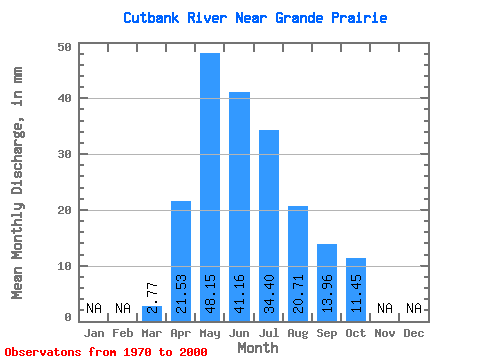
| Statistic | Jan | Feb | Mar | Apr | May | Jun | Jul | Aug | Sep | Oct | Nov | Dec | Annual |
|---|---|---|---|---|---|---|---|---|---|---|---|---|---|
| Mean | 2.77 | 21.53 | 48.14 | 41.16 | 34.39 | 20.70 | 13.96 | 11.44 | |||||
| Standard Deviation | 2.88 | 12.85 | 25.65 | 32.98 | 28.32 | 24.84 | 11.64 | 10.15 | |||||
| Min | 0.35 | 5.80 | 5.33 | 7.09 | 4.79 | 2.36 | 2.04 | 2.02 | |||||
| Max | 13.01 | 46.99 | 118.67 | 130.52 | 120.57 | 98.36 | 45.45 | 51.72 | |||||
| Coefficient of Variation | 1.04 | 0.60 | 0.53 | 0.80 | 0.82 | 1.20 | 0.83 | 0.89 |
 Return to R-Arctic Net Home Page