|
|
|||||||||||||||||
| Point ID: 7439 | Downloads | Plots | Site Data | Code: 70325 |
|
|
|||||||||||||||||
| Download | |
|---|---|
| Site Descriptor Information | Site Time Series Data |
| Link to all available data | |
| View: | Time Series | All |
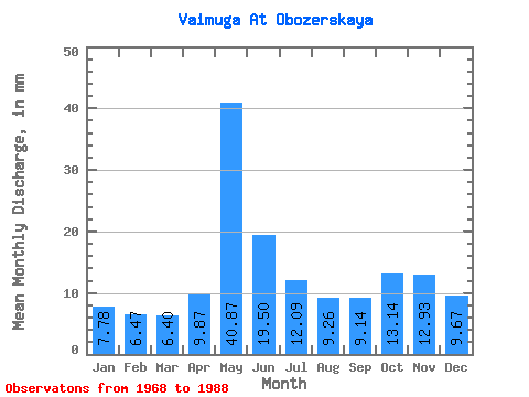
| Units: | m3/s |
| Statistic | Jan | Feb | Mar | Apr | May | Jun | Jul | Aug | Sep | Oct | Nov | Dec | Annual |
|---|---|---|---|---|---|---|---|---|---|---|---|---|---|
| Mean | 7.79 | 6.53 | 6.40 | 9.87 | 40.86 | 19.50 | 12.09 | 9.27 | 9.14 | 13.14 | 12.93 | 9.67 | 157.95 |
| Standard Deviation | 2.71 | 2.31 | 1.80 | 9.70 | 12.05 | 4.90 | 5.92 | 2.38 | 3.94 | 8.48 | 7.27 | 3.10 | 36.85 |
| Min | 2.68 | 2.73 | 2.91 | 3.28 | 24.10 | 8.31 | 7.25 | 6.46 | 6.25 | 6.22 | 5.34 | 5.28 | 112.39 |
| Max | 14.96 | 11.27 | 9.37 | 46.81 | 67.27 | 26.53 | 34.18 | 16.54 | 23.18 | 33.71 | 33.31 | 14.81 | 243.74 |
| Coefficient of Variation | 0.35 | 0.35 | 0.28 | 0.98 | 0.29 | 0.25 | 0.49 | 0.26 | 0.43 | 0.65 | 0.56 | 0.32 | 0.23 |
 Return to R-Arctic Net Home Page