|
|
|||||||||||||||||
| Point ID: 7435 | Downloads | Plots | Site Data | Code: 70304 |
|
|
|||||||||||||||||
| Download | |
|---|---|
| Site Descriptor Information | Site Time Series Data |
| Link to all available data | |
| View: | Time Series | All |
| Units: | m3/s |
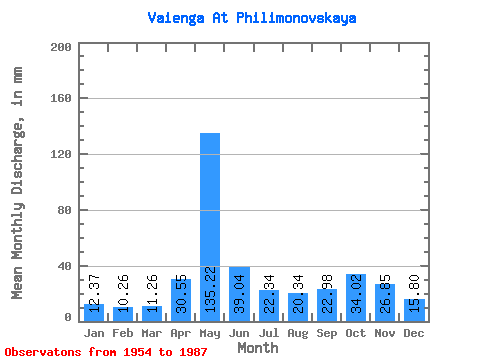
| Statistic | Jan | Feb | Mar | Apr | May | Jun | Jul | Aug | Sep | Oct | Nov | Dec | Annual |
|---|---|---|---|---|---|---|---|---|---|---|---|---|---|
| Mean | 12.37 | 10.35 | 11.26 | 30.55 | 135.20 | 39.04 | 22.34 | 20.33 | 22.98 | 34.02 | 26.84 | 15.80 | 380.99 |
| Standard Deviation | 1.41 | 1.01 | 0.68 | 35.64 | 39.60 | 18.41 | 10.59 | 14.71 | 10.25 | 15.68 | 12.04 | 4.69 | 68.02 |
| Min | 9.35 | 7.91 | 9.96 | 10.81 | 52.91 | 19.20 | 13.23 | 10.23 | 11.12 | 12.90 | 12.49 | 11.17 | 252.29 |
| Max | 16.26 | 13.53 | 12.90 | 201.48 | 215.76 | 81.43 | 61.26 | 73.73 | 52.89 | 81.42 | 61.91 | 29.71 | 509.12 |
| Coefficient of Variation | 0.11 | 0.10 | 0.06 | 1.17 | 0.29 | 0.47 | 0.47 | 0.72 | 0.45 | 0.46 | 0.45 | 0.30 | 0.18 |
 Return to R-Arctic Net Home Page