|
|
|||||||||||||||||
| Point ID: 7434 | Downloads | Plots | Site Data | Code: 70302 |
|
|
|||||||||||||||||
| Download | |
|---|---|
| Site Descriptor Information | Site Time Series Data |
| Link to all available data | |
| View: | Time Series | All |
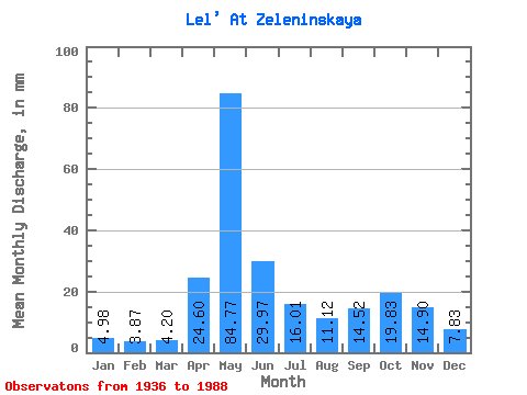
| Units: | m3/s |
| Statistic | Jan | Feb | Mar | Apr | May | Jun | Jul | Aug | Sep | Oct | Nov | Dec | Annual |
|---|---|---|---|---|---|---|---|---|---|---|---|---|---|
| Mean | 4.98 | 3.91 | 4.20 | 24.60 | 84.76 | 29.97 | 16.01 | 11.12 | 14.52 | 19.82 | 14.90 | 7.83 | 236.00 |
| Standard Deviation | 1.50 | 0.93 | 0.79 | 24.01 | 31.10 | 15.50 | 9.33 | 8.79 | 12.17 | 12.35 | 9.54 | 4.55 | 54.65 |
| Min | 2.58 | 2.28 | 2.91 | 4.14 | 30.61 | 9.01 | 4.36 | 4.14 | 3.87 | 4.58 | 4.51 | 3.02 | 138.09 |
| Max | 8.70 | 6.86 | 6.29 | 115.71 | 167.38 | 91.76 | 45.79 | 58.58 | 75.45 | 55.71 | 50.68 | 28.33 | 368.88 |
| Coefficient of Variation | 0.30 | 0.24 | 0.19 | 0.98 | 0.37 | 0.52 | 0.58 | 0.79 | 0.84 | 0.62 | 0.64 | 0.58 | 0.23 |
 Return to R-Arctic Net Home Page