|
|
|||||||||||||||||
| Point ID: 7433 | Downloads | Plots | Site Data | Code: 70301 |
|
|
|||||||||||||||||
| Download | |
|---|---|
| Site Descriptor Information | Site Time Series Data |
| Link to all available data | |
| View: | Time Series | All |
| Units: | m3/s |
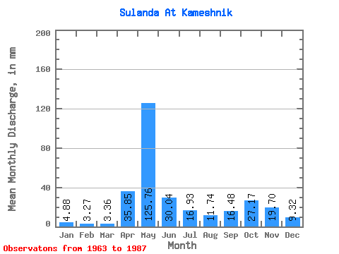
| Statistic | Jan | Feb | Mar | Apr | May | Jun | Jul | Aug | Sep | Oct | Nov | Dec | Annual |
|---|---|---|---|---|---|---|---|---|---|---|---|---|---|
| Mean | 4.88 | 3.30 | 3.36 | 35.85 | 125.74 | 30.04 | 16.93 | 11.74 | 16.48 | 27.16 | 19.70 | 9.32 | 303.97 |
| Standard Deviation | 2.12 | 1.30 | 1.20 | 37.59 | 51.02 | 14.64 | 13.02 | 10.53 | 12.87 | 15.93 | 12.64 | 5.99 | 70.50 |
| Min | 2.18 | 1.59 | 1.09 | 2.74 | 42.51 | 8.55 | 3.67 | 3.38 | 3.83 | 8.10 | 4.57 | 3.52 | 199.91 |
| Max | 12.32 | 6.72 | 6.07 | 148.42 | 247.45 | 66.12 | 41.06 | 50.87 | 53.11 | 66.50 | 50.64 | 28.92 | 459.66 |
| Coefficient of Variation | 0.43 | 0.40 | 0.36 | 1.05 | 0.41 | 0.49 | 0.77 | 0.90 | 0.78 | 0.59 | 0.64 | 0.64 | 0.23 |
 Return to R-Arctic Net Home Page