|
|
|||||||||||||||||
| Point ID: 7432 | Downloads | Plots | Site Data | Code: 70300 |
|
|
|||||||||||||||||
| Download | |
|---|---|
| Site Descriptor Information | Site Time Series Data |
| Link to all available data | |
| View: | Time Series | All |
| Units: | m3/s |
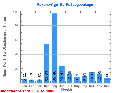
| Statistic | Jan | Feb | Mar | Apr | May | Jun | Jul | Aug | Sep | Oct | Nov | Dec | Annual |
|---|---|---|---|---|---|---|---|---|---|---|---|---|---|
| Mean | 5.22 | 4.21 | 4.83 | 53.87 | 96.44 | 23.41 | 12.97 | 8.72 | 9.69 | 14.82 | 12.75 | 7.08 | 253.99 |
| Standard Deviation | 1.99 | 1.21 | 1.45 | 32.23 | 51.66 | 12.35 | 9.91 | 6.43 | 10.65 | 11.99 | 9.07 | 3.63 | 66.29 |
| Min | 2.15 | 2.35 | 2.79 | 4.87 | 18.40 | 6.00 | 1.77 | 1.21 | 1.39 | 3.07 | 3.00 | 2.29 | 127.46 |
| Max | 12.63 | 6.86 | 9.41 | 133.42 | 218.00 | 74.64 | 52.65 | 36.31 | 58.78 | 57.99 | 43.55 | 20.71 | 414.39 |
| Coefficient of Variation | 0.38 | 0.29 | 0.30 | 0.60 | 0.54 | 0.53 | 0.76 | 0.74 | 1.10 | 0.81 | 0.71 | 0.51 | 0.26 |
 Return to R-Arctic Net Home Page