|
|
|||||||||||||||||
| Point ID: 7428 | Downloads | Plots | Site Data | Code: 70295 |
|
|
|||||||||||||||||
| Download | |
|---|---|
| Site Descriptor Information | Site Time Series Data |
| Link to all available data | |
| View: | Time Series | All |
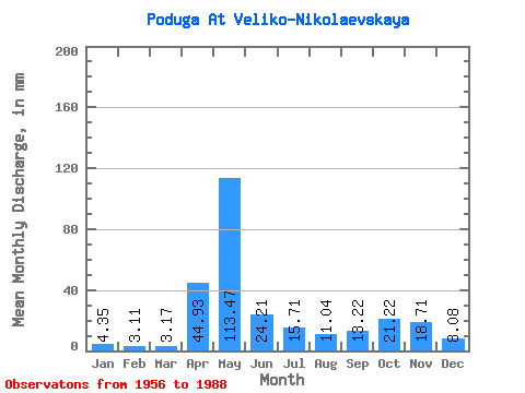
| Units: | m3/s |
| Statistic | Jan | Feb | Mar | Apr | May | Jun | Jul | Aug | Sep | Oct | Nov | Dec | Annual |
|---|---|---|---|---|---|---|---|---|---|---|---|---|---|
| Mean | 4.35 | 3.14 | 3.17 | 44.93 | 113.45 | 24.21 | 15.70 | 11.04 | 13.22 | 21.21 | 18.71 | 8.08 | 279.45 |
| Standard Deviation | 2.38 | 1.44 | 1.04 | 38.01 | 55.29 | 12.63 | 10.20 | 10.63 | 12.04 | 14.78 | 12.94 | 6.15 | 76.75 |
| Min | 0.83 | 1.56 | 1.35 | 2.06 | 27.82 | 6.74 | 2.26 | 1.98 | 1.36 | 3.12 | 3.27 | 1.82 | 189.44 |
| Max | 14.30 | 7.30 | 5.95 | 153.00 | 242.84 | 62.66 | 35.10 | 54.08 | 48.82 | 69.42 | 55.62 | 35.62 | 483.00 |
| Coefficient of Variation | 0.55 | 0.46 | 0.33 | 0.85 | 0.49 | 0.52 | 0.65 | 0.96 | 0.91 | 0.70 | 0.69 | 0.76 | 0.28 |
 Return to R-Arctic Net Home Page