|
|
|||||||||||||||||
| Point ID: 7425 | Downloads | Plots | Site Data | Code: 70291 |
|
|
|||||||||||||||||
| Download | |
|---|---|
| Site Descriptor Information | Site Time Series Data |
| Link to all available data | |
| View: | Time Series | All |
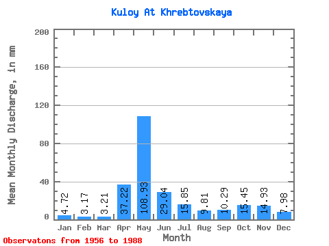
| Units: | m3/s |
| Statistic | Jan | Feb | Mar | Apr | May | Jun | Jul | Aug | Sep | Oct | Nov | Dec | Annual |
|---|---|---|---|---|---|---|---|---|---|---|---|---|---|
| Mean | 4.72 | 3.20 | 3.21 | 37.22 | 108.91 | 29.04 | 15.85 | 9.81 | 10.29 | 15.44 | 14.93 | 7.98 | 259.21 |
| Standard Deviation | 2.22 | 1.23 | 1.11 | 28.54 | 43.14 | 17.49 | 16.86 | 12.10 | 10.89 | 9.62 | 9.80 | 5.25 | 75.55 |
| Min | 2.43 | 1.73 | 1.74 | 3.13 | 28.93 | 5.78 | 2.96 | 2.72 | 2.59 | 3.99 | 3.40 | 2.68 | 142.70 |
| Max | 11.42 | 6.18 | 6.59 | 129.60 | 198.54 | 79.85 | 84.96 | 71.41 | 56.31 | 43.09 | 39.03 | 25.86 | 515.21 |
| Coefficient of Variation | 0.47 | 0.39 | 0.35 | 0.77 | 0.40 | 0.60 | 1.06 | 1.23 | 1.06 | 0.62 | 0.66 | 0.66 | 0.29 |
 Return to R-Arctic Net Home Page