|
|
|||||||||||||||||
| Point ID: 7423 | Downloads | Plots | Site Data | Code: 70284 |
|
|
|||||||||||||||||
| Download | |
|---|---|
| Site Descriptor Information | Site Time Series Data |
| Link to all available data | |
| View: | Time Series | All |
| Units: | m3/s |
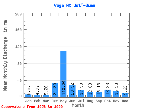
| Statistic | Jan | Feb | Mar | Apr | May | Jun | Jul | Aug | Sep | Oct | Nov | Dec | Annual |
|---|---|---|---|---|---|---|---|---|---|---|---|---|---|
| Mean | 6.56 | 5.01 | 5.25 | 34.80 | 110.02 | 28.32 | 17.89 | 12.08 | 13.13 | 18.23 | 15.53 | 9.61 | 276.26 |
| Standard Deviation | 1.85 | 1.18 | 1.46 | 27.43 | 41.34 | 12.79 | 11.56 | 8.09 | 8.81 | 9.99 | 7.99 | 4.17 | 55.55 |
| Min | 3.59 | 3.26 | 3.96 | 4.92 | 40.87 | 8.86 | 5.26 | 4.74 | 4.69 | 6.77 | 5.71 | 5.02 | 173.38 |
| Max | 11.96 | 7.56 | 12.38 | 109.23 | 202.53 | 66.13 | 50.33 | 46.06 | 39.97 | 52.83 | 36.73 | 25.32 | 385.96 |
| Coefficient of Variation | 0.28 | 0.23 | 0.28 | 0.79 | 0.38 | 0.45 | 0.65 | 0.67 | 0.67 | 0.55 | 0.52 | 0.43 | 0.20 |
 Return to R-Arctic Net Home Page