|
|
|||||||||||||||||
| Point ID: 7420 | Downloads | Plots | Site Data | Code: 70273 |
|
|
|||||||||||||||||
| Download | |
|---|---|
| Site Descriptor Information | Site Time Series Data |
| Link to all available data | |
| View: | Time Series | All |
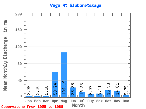
| Units: | m3/s |
| Statistic | Jan | Feb | Mar | Apr | May | Jun | Jul | Aug | Sep | Oct | Nov | Dec | Annual |
|---|---|---|---|---|---|---|---|---|---|---|---|---|---|
| Mean | 3.35 | 2.32 | 2.56 | 59.74 | 106.18 | 23.38 | 13.36 | 8.39 | 9.11 | 16.93 | 14.81 | 5.75 | 264.83 |
| Standard Deviation | 1.87 | 0.99 | 1.14 | 38.24 | 52.01 | 17.66 | 14.44 | 14.06 | 10.41 | 14.09 | 11.83 | 3.88 | 77.75 |
| Min | 1.27 | 0.80 | 1.12 | 3.68 | 17.70 | 2.63 | 1.58 | 0.97 | 1.80 | 3.25 | 2.33 | 1.16 | 174.23 |
| Max | 9.72 | 4.59 | 7.50 | 145.96 | 216.52 | 67.65 | 62.30 | 82.24 | 50.19 | 59.07 | 50.74 | 17.19 | 521.77 |
| Coefficient of Variation | 0.56 | 0.43 | 0.45 | 0.64 | 0.49 | 0.76 | 1.08 | 1.68 | 1.14 | 0.83 | 0.80 | 0.68 | 0.29 |
 Return to R-Arctic Net Home Page