|
|
|||||||||||||||||
| Point ID: 7418 | Downloads | Plots | Site Data | Code: 70270 |
|
|
|||||||||||||||||
| Download | |
|---|---|
| Site Descriptor Information | Site Time Series Data |
| Link to all available data | |
| View: | Time Series | All |
| Units: | m3/s |
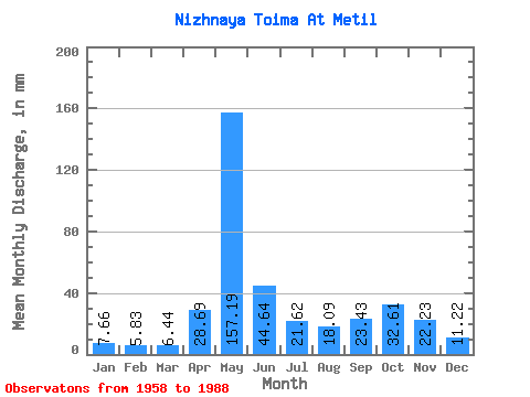
| Statistic | Jan | Feb | Mar | Apr | May | Jun | Jul | Aug | Sep | Oct | Nov | Dec | Annual |
|---|---|---|---|---|---|---|---|---|---|---|---|---|---|
| Mean | 7.66 | 5.88 | 6.44 | 28.68 | 157.17 | 44.65 | 21.61 | 18.09 | 23.43 | 32.61 | 22.23 | 11.22 | 376.61 |
| Standard Deviation | 2.36 | 1.38 | 1.43 | 35.29 | 46.53 | 23.50 | 11.75 | 12.44 | 11.72 | 15.41 | 12.93 | 5.38 | 71.31 |
| Min | 4.61 | 3.80 | 4.03 | 4.75 | 65.44 | 14.33 | 8.60 | 6.81 | 8.15 | 10.96 | 6.21 | 6.03 | 219.14 |
| Max | 14.72 | 9.53 | 10.02 | 171.66 | 266.03 | 109.52 | 49.66 | 59.06 | 54.76 | 82.47 | 56.30 | 26.25 | 522.83 |
| Coefficient of Variation | 0.31 | 0.23 | 0.22 | 1.23 | 0.30 | 0.53 | 0.54 | 0.69 | 0.50 | 0.47 | 0.58 | 0.48 | 0.19 |
 Return to R-Arctic Net Home Page