|
|
|||||||||||||||||
| Point ID: 7417 | Downloads | Plots | Site Data | Code: 70267 |
|
|
|||||||||||||||||
| Download | |
|---|---|
| Site Descriptor Information | Site Time Series Data |
| Link to all available data | |
| View: | Time Series | All |
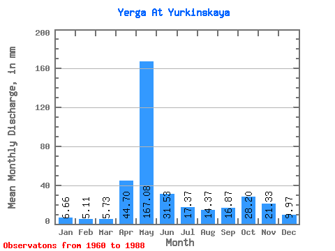
| Units: | m3/s |
| Statistic | Jan | Feb | Mar | Apr | May | Jun | Jul | Aug | Sep | Oct | Nov | Dec | Annual |
|---|---|---|---|---|---|---|---|---|---|---|---|---|---|
| Mean | 6.66 | 5.15 | 5.73 | 44.70 | 167.06 | 31.53 | 17.37 | 14.37 | 16.87 | 28.20 | 21.33 | 9.97 | 366.91 |
| Standard Deviation | 1.90 | 1.34 | 1.17 | 40.72 | 53.62 | 16.26 | 11.84 | 11.49 | 9.55 | 16.55 | 13.48 | 5.33 | 57.97 |
| Min | 3.79 | 2.22 | 2.95 | 5.78 | 43.48 | 8.89 | 5.20 | 5.91 | 6.22 | 8.99 | 6.22 | 4.05 | 233.36 |
| Max | 11.49 | 8.31 | 8.61 | 158.50 | 262.66 | 65.89 | 53.62 | 45.28 | 44.51 | 83.49 | 62.78 | 26.39 | 468.04 |
| Coefficient of Variation | 0.28 | 0.26 | 0.20 | 0.91 | 0.32 | 0.52 | 0.68 | 0.80 | 0.57 | 0.59 | 0.63 | 0.53 | 0.16 |
 Return to R-Arctic Net Home Page