|
|
|||||||||||||||||
| Point ID: 7416 | Downloads | Plots | Site Data | Code: 70258 |
|
|
|||||||||||||||||
| Download | |
|---|---|
| Site Descriptor Information | Site Time Series Data |
| Link to all available data | |
| View: | Time Series | All |
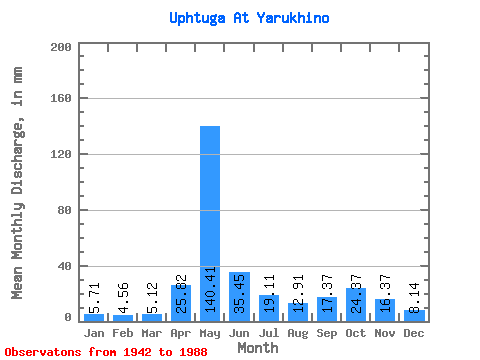
| Units: | m3/s |
| Statistic | Jan | Feb | Mar | Apr | May | Jun | Jul | Aug | Sep | Oct | Nov | Dec | Annual |
|---|---|---|---|---|---|---|---|---|---|---|---|---|---|
| Mean | 5.71 | 4.59 | 5.12 | 25.82 | 140.39 | 35.45 | 19.11 | 12.91 | 17.37 | 24.37 | 16.37 | 8.14 | 314.34 |
| Standard Deviation | 1.44 | 1.00 | 0.77 | 26.86 | 51.58 | 18.53 | 13.22 | 9.32 | 14.95 | 14.54 | 8.87 | 3.40 | 67.53 |
| Min | 3.31 | 2.85 | 3.87 | 4.50 | 39.72 | 9.52 | 5.28 | 4.96 | 5.44 | 6.67 | 4.63 | 4.00 | 163.12 |
| Max | 9.91 | 6.60 | 7.00 | 112.76 | 241.32 | 106.90 | 66.42 | 47.05 | 94.45 | 80.19 | 36.39 | 22.62 | 565.09 |
| Coefficient of Variation | 0.25 | 0.22 | 0.15 | 1.04 | 0.37 | 0.52 | 0.69 | 0.72 | 0.86 | 0.60 | 0.54 | 0.42 | 0.21 |
 Return to R-Arctic Net Home Page