|
|
|||||||||||||||||
| Point ID: 7410 | Downloads | Plots | Site Data | Code: 70246 |
|
|
|||||||||||||||||
| Download | |
|---|---|
| Site Descriptor Information | Site Time Series Data |
| Link to all available data | |
| View: | Time Series | All |
| Units: | m3/s |
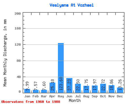
| Statistic | Jan | Feb | Mar | Apr | May | Jun | Jul | Aug | Sep | Oct | Nov | Dec | Annual |
|---|---|---|---|---|---|---|---|---|---|---|---|---|---|
| Mean | 9.99 | 7.63 | 7.60 | 25.18 | 123.59 | 37.23 | 22.50 | 17.74 | 17.97 | 22.72 | 18.86 | 13.26 | 321.62 |
| Standard Deviation | 2.53 | 1.61 | 1.12 | 27.91 | 38.26 | 13.67 | 11.58 | 9.34 | 7.53 | 9.48 | 7.25 | 4.95 | 55.97 |
| Min | 7.41 | 5.84 | 6.23 | 6.58 | 62.67 | 16.18 | 10.94 | 7.48 | 7.11 | 8.84 | 8.09 | 7.07 | 198.76 |
| Max | 20.05 | 14.06 | 11.35 | 126.31 | 196.43 | 78.94 | 68.65 | 48.05 | 41.77 | 58.39 | 34.87 | 34.12 | 457.25 |
| Coefficient of Variation | 0.25 | 0.21 | 0.15 | 1.11 | 0.31 | 0.37 | 0.52 | 0.53 | 0.42 | 0.42 | 0.38 | 0.37 | 0.17 |
 Return to R-Arctic Net Home Page