|
|
|||||||||||||||||
| Point ID: 7409 | Downloads | Plots | Site Data | Code: 70244 |
|
|
|||||||||||||||||
| Download | |
|---|---|
| Site Descriptor Information | Site Time Series Data |
| Link to all available data | |
| View: | Time Series | All |
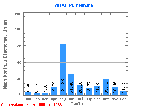
| Units: | m3/s |
| Statistic | Jan | Feb | Mar | Apr | May | Jun | Jul | Aug | Sep | Oct | Nov | Dec | Annual |
|---|---|---|---|---|---|---|---|---|---|---|---|---|---|
| Mean | 8.54 | 6.53 | 7.09 | 19.99 | 124.81 | 51.40 | 26.38 | 18.77 | 21.75 | 39.02 | 20.46 | 11.65 | 354.31 |
| Standard Deviation | 2.55 | 1.74 | 1.61 | 23.94 | 37.79 | 30.83 | 12.93 | 8.04 | 8.96 | 64.59 | 8.49 | 3.67 | 100.88 |
| Min | 4.00 | 2.92 | 4.15 | 4.33 | 77.61 | 22.81 | 11.30 | 6.92 | 10.37 | 12.27 | 9.06 | 6.30 | 197.08 |
| Max | 14.51 | 10.47 | 10.42 | 115.93 | 232.74 | 156.46 | 64.66 | 41.39 | 50.33 | 370.05 | 39.77 | 20.55 | 742.24 |
| Coefficient of Variation | 0.30 | 0.27 | 0.23 | 1.20 | 0.30 | 0.60 | 0.49 | 0.43 | 0.41 | 1.66 | 0.41 | 0.32 | 0.28 |
 Return to R-Arctic Net Home Page