|
|
|||||||||||||||||
| Point ID: 7408 | Downloads | Plots | Site Data | Code: 70242 |
|
|
|||||||||||||||||
| Download | |
|---|---|
| Site Descriptor Information | Site Time Series Data |
| Link to all available data | |
| View: | Time Series | All |
| Units: | m3/s |
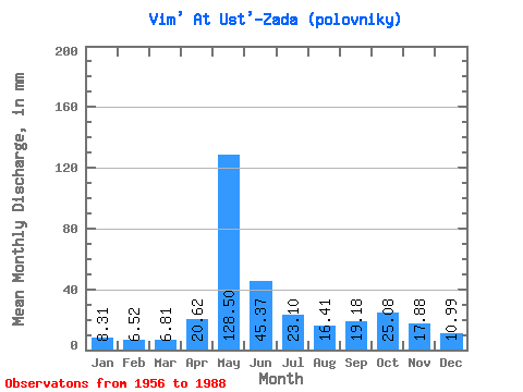
| Statistic | Jan | Feb | Mar | Apr | May | Jun | Jul | Aug | Sep | Oct | Nov | Dec | Annual |
|---|---|---|---|---|---|---|---|---|---|---|---|---|---|
| Mean | 8.31 | 6.57 | 6.81 | 20.62 | 128.49 | 45.38 | 23.09 | 16.41 | 19.18 | 25.07 | 17.88 | 10.99 | 326.88 |
| Standard Deviation | 1.39 | 0.87 | 0.64 | 22.76 | 36.76 | 22.43 | 12.18 | 7.91 | 8.02 | 9.98 | 7.33 | 3.06 | 54.06 |
| Min | 6.44 | 5.26 | 5.38 | 5.74 | 81.94 | 20.14 | 9.84 | 7.98 | 7.88 | 9.42 | 7.82 | 6.34 | 207.35 |
| Max | 12.48 | 8.92 | 8.39 | 111.53 | 196.32 | 116.69 | 69.35 | 44.38 | 43.89 | 54.41 | 41.31 | 22.51 | 450.31 |
| Coefficient of Variation | 0.17 | 0.13 | 0.09 | 1.10 | 0.29 | 0.49 | 0.53 | 0.48 | 0.42 | 0.40 | 0.41 | 0.28 | 0.17 |
 Return to R-Arctic Net Home Page