|
|
|||||||||||||||||
| Point ID: 7402 | Downloads | Plots | Site Data | Code: 70228 |
|
|
|||||||||||||||||
| Download | |
|---|---|
| Site Descriptor Information | Site Time Series Data |
| Link to all available data | |
| View: | Time Series | All |
| Units: | m3/s |
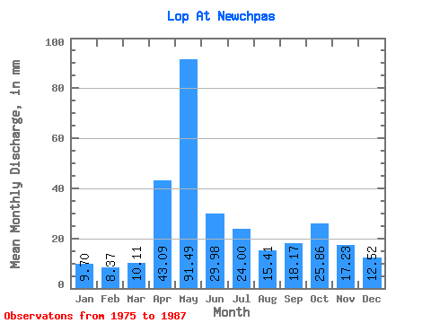
| Statistic | Jan | Feb | Mar | Apr | May | Jun | Jul | Aug | Sep | Oct | Nov | Dec | Annual |
|---|---|---|---|---|---|---|---|---|---|---|---|---|---|
| Mean | 9.70 | 8.44 | 10.11 | 43.09 | 91.48 | 29.98 | 23.99 | 15.40 | 18.16 | 25.86 | 17.23 | 12.52 | 277.48 |
| Standard Deviation | 2.48 | 1.82 | 2.00 | 31.65 | 34.79 | 11.23 | 10.95 | 5.46 | 6.95 | 11.49 | 5.29 | 2.42 | 28.95 |
| Min | 5.44 | 5.62 | 6.35 | 9.82 | 38.98 | 17.43 | 12.84 | 10.33 | 10.70 | 16.13 | 11.81 | 8.82 | 249.76 |
| Max | 11.47 | 10.95 | 12.71 | 97.31 | 133.90 | 50.42 | 43.87 | 28.24 | 32.47 | 54.38 | 26.01 | 15.63 | 307.52 |
| Coefficient of Variation | 0.26 | 0.22 | 0.20 | 0.73 | 0.38 | 0.38 | 0.46 | 0.35 | 0.38 | 0.45 | 0.31 | 0.19 | 0.10 |
 Return to R-Arctic Net Home Page