|
|
|||||||||||||||||
| Point ID: 7392 | Downloads | Plots | Site Data | Code: 70207 |
|
|
|||||||||||||||||
| Download | |
|---|---|
| Site Descriptor Information | Site Time Series Data |
| Link to all available data | |
| View: | Time Series | All |
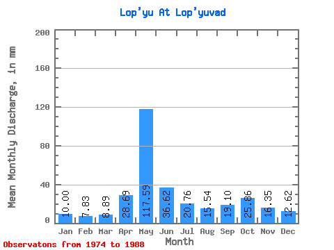
| Units: | m3/s |
| Statistic | Jan | Feb | Mar | Apr | May | Jun | Jul | Aug | Sep | Oct | Nov | Dec | Annual |
|---|---|---|---|---|---|---|---|---|---|---|---|---|---|
| Mean | 10.00 | 7.90 | 8.89 | 28.69 | 117.58 | 36.62 | 20.75 | 15.54 | 19.10 | 25.85 | 16.35 | 12.62 | 322.36 |
| Standard Deviation | 2.23 | 1.10 | 1.18 | 28.02 | 40.92 | 14.73 | 10.54 | 6.48 | 7.07 | 12.76 | 6.64 | 4.12 | 54.86 |
| Min | 6.10 | 6.17 | 6.19 | 7.42 | 42.13 | 14.55 | 12.06 | 8.59 | 9.21 | 9.51 | 8.40 | 6.96 | 221.31 |
| Max | 14.81 | 9.86 | 10.37 | 99.48 | 190.88 | 67.35 | 49.16 | 32.24 | 34.29 | 52.35 | 29.75 | 19.53 | 389.48 |
| Coefficient of Variation | 0.22 | 0.14 | 0.13 | 0.98 | 0.35 | 0.40 | 0.51 | 0.42 | 0.37 | 0.49 | 0.41 | 0.33 | 0.17 |
 Return to R-Arctic Net Home Page