|
|
|||||||||||||||||
| Point ID: 7391 | Downloads | Plots | Site Data | Code: 70206 |
|
|
|||||||||||||||||
| Download | |
|---|---|
| Site Descriptor Information | Site Time Series Data |
| Link to all available data | |
| View: | Time Series | All |
| Units: | m3/s |
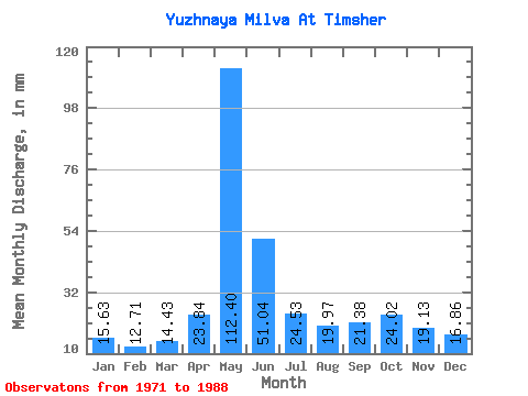
| Statistic | Jan | Feb | Mar | Apr | May | Jun | Jul | Aug | Sep | Oct | Nov | Dec | Annual |
|---|---|---|---|---|---|---|---|---|---|---|---|---|---|
| Mean | 15.63 | 12.82 | 14.43 | 23.84 | 112.39 | 51.04 | 24.52 | 19.97 | 21.39 | 24.01 | 19.13 | 16.85 | 354.44 |
| Standard Deviation | 1.90 | 1.71 | 1.88 | 14.03 | 33.13 | 30.87 | 8.68 | 4.91 | 5.58 | 7.68 | 4.81 | 2.63 | 42.21 |
| Min | 12.51 | 9.13 | 10.94 | 10.72 | 71.34 | 18.02 | 14.62 | 14.47 | 14.92 | 14.15 | 12.29 | 12.00 | 265.95 |
| Max | 18.40 | 14.83 | 16.84 | 65.49 | 210.56 | 134.15 | 48.04 | 35.98 | 32.84 | 44.77 | 32.45 | 20.65 | 436.40 |
| Coefficient of Variation | 0.12 | 0.13 | 0.13 | 0.59 | 0.29 | 0.60 | 0.35 | 0.25 | 0.26 | 0.32 | 0.25 | 0.16 | 0.12 |
 Return to R-Arctic Net Home Page