|
|
|||||||||||||||||
| Point ID: 7390 | Downloads | Plots | Site Data | Code: 70205 |
|
|
|||||||||||||||||
| Download | |
|---|---|
| Site Descriptor Information | Site Time Series Data |
| Link to all available data | |
| View: | Time Series | All |
| Units: | m3/s |
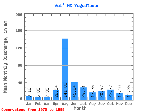
| Statistic | Jan | Feb | Mar | Apr | May | Jun | Jul | Aug | Sep | Oct | Nov | Dec | Annual |
|---|---|---|---|---|---|---|---|---|---|---|---|---|---|
| Mean | 9.16 | 6.88 | 7.33 | 22.54 | 141.81 | 41.84 | 29.31 | 17.76 | 20.96 | 23.77 | 17.10 | 11.25 | 347.77 |
| Standard Deviation | 2.69 | 2.45 | 2.66 | 30.72 | 42.82 | 22.36 | 17.83 | 12.48 | 8.49 | 9.45 | 7.44 | 4.23 | 69.01 |
| Min | 5.24 | 3.79 | 4.40 | 4.70 | 82.98 | 12.09 | 8.84 | 6.41 | 8.99 | 14.35 | 9.02 | 5.96 | 214.72 |
| Max | 12.91 | 10.40 | 12.13 | 115.39 | 227.36 | 95.68 | 65.30 | 50.33 | 39.14 | 49.13 | 38.85 | 20.82 | 469.25 |
| Coefficient of Variation | 0.29 | 0.36 | 0.36 | 1.36 | 0.30 | 0.53 | 0.61 | 0.70 | 0.41 | 0.40 | 0.43 | 0.38 | 0.20 |
 Return to R-Arctic Net Home Page