|
|
|||||||||||||||||
| Point ID: 7388 | Downloads | Plots | Site Data | Code: 70184 |
|
|
|||||||||||||||||
| Download | |
|---|---|
| Site Descriptor Information | Site Time Series Data |
| Link to all available data | |
| View: | Time Series | All |
| Units: | m3/s |
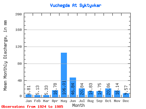
| Statistic | Jan | Feb | Mar | Apr | May | Jun | Jul | Aug | Sep | Oct | Nov | Dec | Annual |
|---|---|---|---|---|---|---|---|---|---|---|---|---|---|
| Mean | 6.81 | 5.17 | 5.33 | 16.78 | 105.99 | 46.84 | 20.84 | 14.83 | 14.75 | 20.86 | 16.14 | 9.57 | 282.38 |
| Standard Deviation | 1.84 | 1.23 | 1.20 | 14.17 | 28.90 | 21.36 | 9.63 | 8.15 | 8.31 | 8.76 | 6.87 | 2.87 | 51.62 |
| Min | 3.35 | 2.69 | 2.73 | 3.65 | 37.79 | 13.37 | 7.21 | 6.00 | 5.81 | 7.17 | 6.16 | 5.36 | 141.41 |
| Max | 13.93 | 9.08 | 9.01 | 67.80 | 175.73 | 106.55 | 53.24 | 48.84 | 50.76 | 46.44 | 37.00 | 19.73 | 397.37 |
| Coefficient of Variation | 0.27 | 0.24 | 0.23 | 0.84 | 0.27 | 0.46 | 0.46 | 0.55 | 0.56 | 0.42 | 0.43 | 0.30 | 0.18 |
 Return to R-Arctic Net Home Page