|
|
|||||||||||||||||
| Point ID: 7383 | Downloads | Plots | Site Data | Code: 70174 |
|
|
|||||||||||||||||
| Download | |
|---|---|
| Site Descriptor Information | Site Time Series Data |
| Link to all available data | |
| View: | Time Series | All |
| Units: | m3/s |
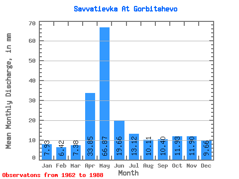
| Statistic | Jan | Feb | Mar | Apr | May | Jun | Jul | Aug | Sep | Oct | Nov | Dec | Annual |
|---|---|---|---|---|---|---|---|---|---|---|---|---|---|
| Mean | 7.96 | 6.47 | 7.35 | 33.85 | 66.84 | 19.67 | 13.09 | 10.11 | 10.37 | 11.94 | 11.87 | 9.64 | 208.55 |
| Standard Deviation | 2.40 | 2.56 | 2.43 | 26.03 | 36.27 | 11.58 | 6.35 | 3.25 | 3.76 | 3.33 | 3.76 | 2.59 | 42.92 |
| Min | 2.82 | 0.33 | 3.83 | 6.26 | 13.66 | 7.49 | 6.74 | 6.38 | 5.91 | 6.01 | 5.29 | 5.56 | 103.32 |
| Max | 11.84 | 11.62 | 13.66 | 100.51 | 141.19 | 59.95 | 32.79 | 20.95 | 24.69 | 19.13 | 22.04 | 17.31 | 269.98 |
| Coefficient of Variation | 0.30 | 0.40 | 0.33 | 0.77 | 0.54 | 0.59 | 0.48 | 0.32 | 0.36 | 0.28 | 0.32 | 0.27 | 0.21 |
 Return to R-Arctic Net Home Page